Sunday 17th October 1819
Sunday Oct 17th We went to a small English Chapel in York Place in the morning afterwards we made some visits & walked to Calton Hill from the top of
of Nelsons monument there is an uncommon fine view of Edinburgh
OBSERVATIONS & COMMENTS:
St Paul’s & St George’s Church 46 York Place, Edinburgh, was designed by Archibald Elliott, 1818, in perpendicular Gothic with octagonal corner turrets, pierced parapets and crocketted finials.
1829: St George's Chapel, York Place, Edinburgh from page 87 of Modern Athens, displayed in a series of views; or, Edinburgh in the nineteenth century; exhibiting the whole of the new buildings, modern improvements, antiquities, & picturesque scenery of the Scottish metropolis & its environs, by Thomas Hosmer Shepherd. Original held and digitised by the British Library (Accession number HMNTS 010370.dd.10.) This work is in the public domain. https://commons.wikimedia.org/wiki/File:MA(1829)_p.087_-_St_George%27s_Chapel,_York_Place,_Edinburgh_-_Thomas_Hosmer_Shepherd.jpg
Matching sanctuary added by Peddie & Kinnear, 1892. https://scotlandschurchestrust.org.uk/church/st-pauls-st-georges-church-edinburgh/ The photograph below shows the larger church (the chapel together with the matching sanctuary) as it is today.
St Paul's and St George's Church, York Place, Edinburgh . © Copyright Mike Pennington and licensed for reuse under the (CC BY-SA 2.0) Creative Commons Licence. https://www.geograph.org.uk/photo/5417273
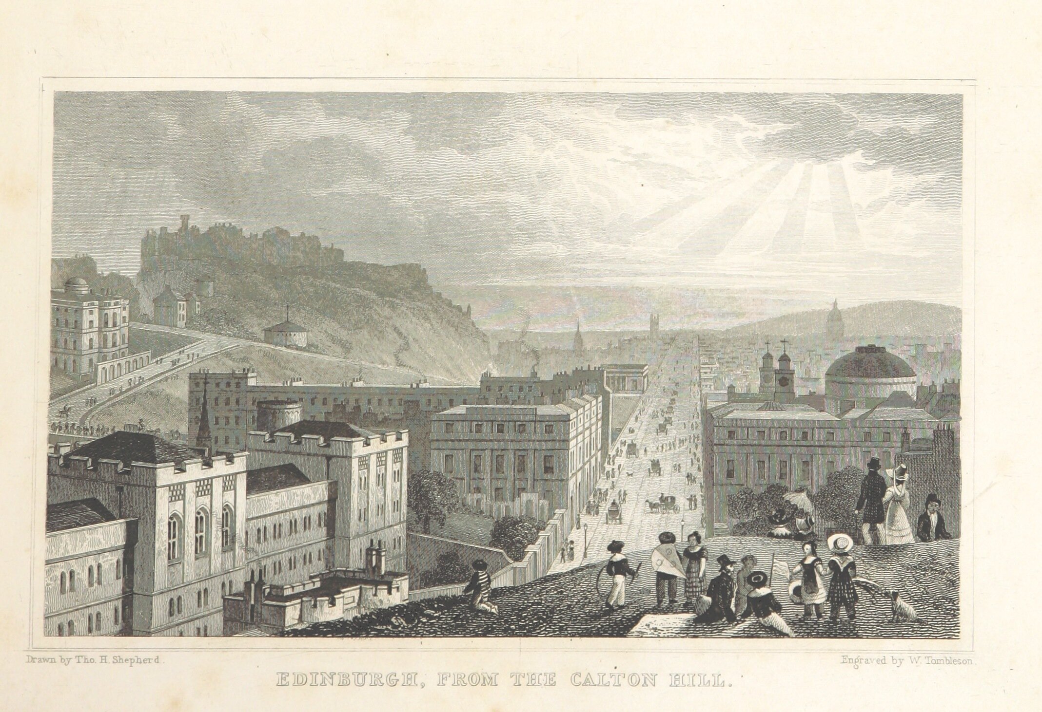
Calton Hill is situated beyond the east end of Princes Street and included in the city's UNESCO World Heritage Site. Views of, and from, the hill are often used in photographs and paintings of the city. Calton Hill is the headquarters of the Scottish Government, which is based at St Andrew's House, on the steep southern slope of the hill. The Scottish Parliament Building and other notable buildings such as Holyrood Palace lie near the foot of the hill.
1829: Edinburgh, from the Calton Hill from page 55 of Modern Athens, displayed in a series of views; or, Edinburgh in the nineteenth century; exhibiting the whole of the new buildings, modern improvements, antiquities, & picturesque scenery of the Scottish metropolis & its environs, by Thomas Hosmer Shepherd. Original held and digitised by the British Library (Accession number HMNTS 010370.dd.10.) This work is in the public domain. https://commons.wikimedia.org/wiki/File:MA(1829)_p.055_-_Edinburgh,_from_the_Calton_Hill_-_Thomas_Hosmer_Shepherd.jpg
Calton Hill is also the location of several iconic monuments and buildings: the National Monument, the Nelson Monument, the Dugald Stewart Monument, the old Royal High School, the Robert Burns Monument and the Political Martyrs' Monument.
Waterloo Place, the National and Nelson's Monuments, Calton Hill, etc, Edinburgh from page 73 of Modern Athens, displayed in a series of views; or, Edinburgh in the nineteenth century; exhibiting the whole of the new buildings, modern improvements, antiquities, & picturesque scenery of the Scottish metropolis & its environs, by Thomas Hosmer Shepherd. Original held and digitised by the British Library (Accession number HMNTS 010370.dd.10.) This work is in the public domain. https://commons.wikimedia.org/wiki/File:MA(1829)_p.073_-_Waterloo_Place,_the_National_and_Nelson%27s_Monuments,_Calton_Hill,_etc,_Edinburgh_-_Thomas_Hosmer_Shepherd.jpg
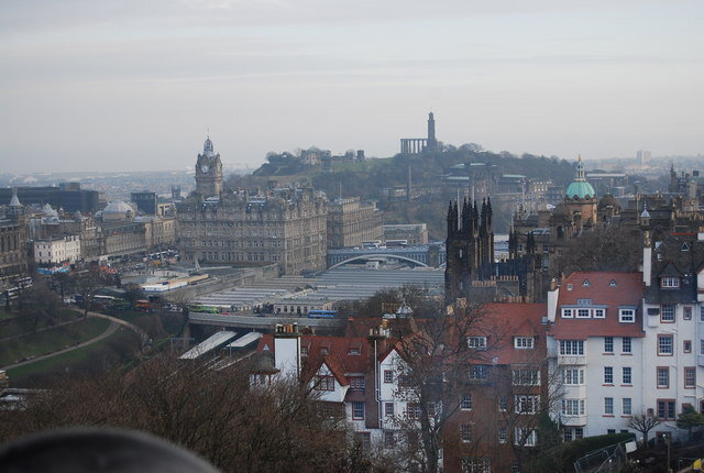
Edinburgh cityscape. Waverley Station and Calton Hill can be seen.© Copyright N Chadwick and licensed for reuse under the (CC BY-SA 2.0) Creative Commons Licence. https://www.geograph.org.uk/photo/2322243
In 1787, the artist Robert Barker, inspired by walking on the hill created the world’s first panorama - an immersive 360 degree view depicting Edinburgh from the tower of the City Observatory at the summit of Calton Hill. https://en.wikipedia.org/wiki/Calton_Hill
1829: North Bridge, Calton Hill, etc, from the Bank of Scotland from page 81 of Modern Athens, displayed in a series of views; or, Edinburgh in the nineteenth century; exhibiting the whole of the new buildings, modern improvements, antiquities, & picturesque scenery of the Scottish metropolis & its environs, by Thomas Hosmer Shepherd. Original held and digitised by the British Library (Accession number HMNTS 010370.dd.10.) This work is in the public domain. https://commons.wikimedia.org/wiki/File:MA(1829)_p.081_-_North_Bridge,_Calton_Hill,_etc,_from_the_Bank_of_Scotland_-_Thomas_Hosmer_Shepherd.jpg
Nelsons monument was built between 1807 and 1815 to commemorate Nelson's victory over the French and Spanish fleets at the Battle of Trafalgar in 1805, and his own death at the same battle.
1829: Nelson's Monument, Calton Hill from page 119 of Modern Athens, displayed in a series of views; or, Edinburgh in the nineteenth century; exhibiting the whole of the new buildings, modern improvements, antiquities, & picturesque scenery of the Scottish metropolis & its environs, by Thomas Hosmer Shepherd. Original held and digitised by the British Library (Accession number HMNTS 010370.dd.10.) This work is in the public domain. https://commons.wikimedia.org/wiki/File:MA(1829)_p.119_-_Nelson%27s_Monument,_Calton_Hill_-_Thomas_Hosmer_Shepherd.jpg
The tower was intended as a signal mast, attended by sailors who would be accommodated within the ground floor rooms, although these were in use as a tea room by 1820.
Nelson Monument on the Calton Hill . © Copyright kim traynor and licensed for reuse under the (CC BY-SA 2.0) CreativeCommons Licence. https://www.geograph.org.uk/photo/1945314
Public access was available from the start, for a small fee. The Royal Navy's White Ensign and signal flags spelling out Nelson's famous message "England expects that every man will do his duty" are flown from the Monument on Trafalgar Day each year. https://en.wikipedia.org/wiki/Nelson_Monument,_Edinburgh
“The Nelson Monument built on Glasgow Green in 1806 was the first major tribute in stone to the 'Hero of Trafalgar', but Robert Burn's tower on the Calton Hill, built in the shape of a telescope, was a close runner-up. Work on the 106ft high structure, paid for by public subscription, began in 1807 and was completed in 1816. Thus, patriotic North Britons demonstrated their gratitude for Nelson's victory some thirty years before London erected”. https://www.geograph.org.uk/photo/1945314
“An uncommon fine view” from Nelson’s monument
Nelson Monument view of Holyrood Palace © Copyright kim traynor and licensed for reuse under the (CC BY-SA 2.0) Creative Commons Licence. https://www.geograph.org.uk/photo/1516594
Nelson Monument view of the Canongate. © Copyright kim traynor and licensed for reuse under the (CC BY-SA 2.0) Creative Commons Licence. https://www.geograph.org.uk/photo/1516578
Lucy would not have had the magnificent view, below, of the National Monument, photographed by Kim Traynor, which began construction in 1822.
Nelson Monument view of the National Monument . © Copyright kim traynor and licensed for reuse under the (CC BY-SA 2.0) Creative Commons Licence. https://www.geograph.org.uk/photo/1516553
The contributor, Kim Traynor, adds these comments to his photograph on Geograph: “Begun in 1822, Scotland's National Monument to the fallen in the Napoleonic Wars was to be a church designed by Charles Robert Cockerell and William Henry Playfair and modelled on the Parthenon on the Acropolis of Athens. Only the portico was built. The pillars of Craigleith sandstone, each weighing between 10 and 15 tons and costing over £1,000, were to be paid for by public subscription. The donations dried up, however, and work had to be stopped in 1829, leaving behind an instant ruin that has become one of the most recognisable landmarks on the Edinburgh skyline. And thus while London is the Rome of the empire, to which the young, and the ambitious, and the gay, resort for the pursuit of pleasure, of fortune, or of ambition, Edinburgh might become another Athens, in which the arts and the sciences flourished, under the shade of her ancient fame, and established a dominion over the minds of men more permanent than even that which the Roman arms were able to effect. -- Sir Archibald Alison, historian, quoted in Blackwood's magazine” https://www.geograph.org.uk/photo/1516553
Nelson Monument view towards Leith . © Copyright kim traynor and licensed for reuse under the (CC BY-SA 2.0) Creative Commons Licence. https://www.geograph.org.uk/photo/1516547
Kim Traynor comments on the intense development of this view towards Leith: “Housing statistics reveal the area between Easter Road and Leith Walk to be the most densely populated part of Edinburgh, but it wasn't always so...” He adds two poignant comments, written nearly a century apart: There scarcely can be a finer view than that from the Calton Hill, which rises from the town of Edinburgh. I have never seen the view of Naples, to its Bay, but I am told, those who have seen both, are in doubt to which of the two to give the preference. On gaining the summit of Calton Hill, a grand view presents itself to the North, over the flat ground of a mile and a half, between Edinburgh and Leith, enriched by villas, gardens, woods, and fine land; over which is seen the town of Leith; its road, crowded with ships, and the Forth, like an arm of the sea, seven miles broad, flowing from Stirling to the German Ocean; with the mountains of Fife closing the scene. (...) But as that hill is common, daily, and nightly lounge of all the common vagabonds and loose tribe of the town, the walk over it must be taken with a gentleman in company, else women of decency will be insulted.-- Sarah Murray, A Companion And Useful Guide To The Beauties Of Scotland, 1799
Now all the ground eastward of the Walk to Easter Road is rapidly being covered by new streets, and the last of the green fields there has well-nigh disappeared. Between the North British Goods Station and Lorne Street the ground fronting the Walk belongs to the Governors of Heriot's Hospital, while the ground between the latter and the Easter Road is the property of the Trinity Hospital. The ground in these districts has been feued at from £105 to £120 per acre, for tenements four storeys in height, at an average value each of from £1,800 to £2,000. Many of these streets are devoid of architectural features and meant for the residence of artisans. -- James Grant, Old And New Edinburgh, Vol.III, 1883 https://www.geograph.org.uk/photo/1516547
Can you help us?
Old Regency Prints, Pictures an Coaching maps: Do you have access to any prints or pictures showing what town and country would have looked like when Lucy travelled through? Any illustrations of what she would have seen in 1819 will enliven our research.
New Pictures: Do you have any modern pictures of the streets, buildings, gardens and views that would enable us to see the changes that two centuries have wrought?


